| MAFLA Formation |
|
|
|
|
|
|
|
|
|
|
|
|
|
|
Arkosic Conglomerate
Norphlet Equivalent
Washington County,
Mississippi
Eolian Norphlet Sand
Norphlet Seif Dune
ARKOSES, DUNES AND AN IMPORTANT RULE OF THUMB
The Norphlet Formation is an Upper Jurassic clastic unit that was deposited atop the Louann Salt in most areas of Mississippi, Alabama and Louisiana. While this contact is inferred to be conformable in most areas, this geologist has also observed on seismic data what appear to be large erosional events (i.e., canyons, etc.) attributable to the Norphlet that have removed large volumes of the underlying Louann Salt.
Based upon well penetrations in Mississippi and Alabama, the Norphlet can be subdivided into three general facies, all of which were deposited under arid climactic conditions. From bottom (oldest) to top (youngest), they are as follows:
Basal Norphlet Shale - atop the Louann Salt, a thin black shale is often encountered in wells that penetrate the entire Norphlet section. This basal shale should not to be confused with the fine silts that occupy the interdunal areas of the eolian facies (discussed below). The Basal Norphlet Shale rarely exceeds 50 feet in total thickness. In western Mississippi, the Basal Norphlet Shale thins to less than five feet, and in some areas it (and the rest of the Norphlet facies) is completely absent. It is important to recognize those geomorphic areas where the Basal Norphlet Shale is very thin or absent; in those areas, significant erosion of the Louann by the transgressing Smackover sea has been observed.
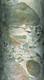
Arkosic Lower Norphlet - in southwest Alabama, several deep Norphlet penetrations have encountered an immature, arkosic facies of the Norphlet that is clearly distinguishable from the classic eolian facies that overlies it. It appears that this early pulse of Norphlet sediments resulted from the erosion of the Appalachian highlands located just north and east of the study area. The arkosic facies owes its pinkish-red color to the presence of significant amounts of plagioclase feldspar and other feldspathic fragments as well as ferrous oxides. Measured porosity and permeability can be quite good (20% porosity being fairly common), presumably due to the prevention of quartz overgrowths by some clay constituents as well as the post-depositional leaching of other constituents. In the updip areas of the Gulf Coast, a "granite wash" has been encountered in many wells that appears to represent the updip equivalent of the arkosic facies, comprised of conglomeratic sediments from coalesced alluvial fans (for a striking example of these comglomeratic sediments, see the core photo at left).
Since most Norphlet penetrations reached total depth in the upper, eolian portion of the unit, little is known about this intriguing, underlying older arkosic facies. As mentioned above, seismic data indicates that there are several large canyons eroded into the Louann Salt attributable to this arkosic facies that are totally undocumented in the current literature. In most areas of northeast Texas and southwest Arkansas, the Norphlet clastics that have been encountered to date have been generally very thin, but alluvial fans of Norphlet age apparently were weathered from - and deposited on - the flanks of Triassic volcanoes, and redeposited as reworked arkosic sediments in the wadis that formed in the valleys between the volcanic complexes, which were essentially inselbergs at the time of (arid) Norphlet deposition. The Norphlet sediments deposited around the inselbergs of northern Cass County, Texas (just north of Rodessa Field) represent an excellent example of this depositional environment, with small oil pools having been discovered in the Norphlet arkosic wadi facies in Frazier Creek and Colville Fields. Because of the arkosic nature of the sediments, which contain appreciable amounts of iron and clay minerals, the producing resistivity of the Norphlet oil pools is fairly low; click here to view two examples of Norphlet production from the northern Cass County area. Local nomenclature in the northeast Texas and southwest Arkansas can be confusing, in that the alluvial fans and wadis of the Norphlet are often called "Eagle Mills"; the use of this nomenclature is certainly understandable, since the clastics in question are sediments eroded from the Eagle Mills - aged volcanic complexes; but in Mississippi and Alabama, these reworked sediments are generally assigned to the Norphlet, even in the central Mississippi area, where similar Eagle Mills volcanic complexes (and flanking alluvial fans) have been encountered.
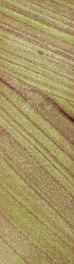
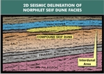
Eolian Upper Norphlet - easily the most recognizable facies of the Norphlet, the eolian sediments that comprise the upper part of the Norphlet are typified by classic eolian characteristics such as high-angle cross-bedding, frosted grains, and uniquely wind-shaped geomorphological features (see the core photo at lower left of cross-bedded Norphlet "seif" dune sediments). Constrained by existing well control, this eolian facies has been encountered across southern Alabama, southwestern Mississippi, and their offshore state and federal waters. In central Choctaw County, Alabama, the upper Norphlet is characterized by a uniform deposition of long seif dunes that are dip oriented (i.e., trend northeast-southwest); these dunes are approximately one mile in width (from interdunal axis to interdunal axis), as much as 20 miles long, and up to 800 feet in thickness along their narrow crestal axes. Please click here to view an annotated 2D seismic example of a Norphlet seif dune in Alabama; to view a more concisely-annotated 3D example, please click here.
Across the state line into Mississippi, another series of seif dunes trend perpendicular to those in Choctaw County; in Clarke County, Mississippi, for example, the seif dunes are aligned north-south. These two seif dune trends appear to coalesce in the Greene County, Mississippi / southern Washington County, Alabama area, resulting in the formation of large "star" dunes. To the southeast of that area, in the prolific Norphlet Gas Trend of the greater Mobile Bay / OCS area, a similar trend of Norphlet seif dunes are also aligned almost north-south. Seif dunes in the Norphlet have been encountered as far south as the Destin Dome OCS area south of Pensacola, Florida, and three recent discoveries in the Deepwater Norphlet Play (Gettysburg, Appomattox, Vicksburg Fields) suggest that the eolian Norphlet play has now been extended over 80 miles offshore, under 7,500 feet of water. Shell and its partners, Ecopetrol and CNOOC, estimate total Deepwater Norphlet recoverable reserves now total approximately 700 million barrels of oil.
At the very top of the Norphlet, a reworked, reprecipitated Norphlet clastic facies is often encountered. This facies, informally named the "Denkmann Sand" in some areas of Mississippi, appears to have been reworked by the encroaching Lower Smackover Brown Dense sea, and is typically hard, dense, white, and nonporous. The interval contains reprecipitated quartz and considerable pyrite precipitated as a result of the chemical interaction of hydrogen sulfide generated by the overlying Brown Dense Limestone with the iron-bearing constituents of the Norphlet. The mineral content of this interval will sometimes present an odd separation of the density-neutron curves on porosity logs, not unlike that of the so-called "gas effect" observed in very porous sandstones; it appears the density curve is the curve that is affected, yielding erroneously high porosity values. Conversely, the neutron log, which typically indicates zero porosity in such circumstances, is correctly measuring the (lack of) porosity in such sediments; the porosity having been totally occluded by the reprecipitated quartz and pyrite.
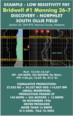
The SP (Spontaneous Potential) Curve is one log curve that should not be used to condemn a sandstone logged in the Norphlet Sand interval. Many prolific Norphlet Sand wells exhibit little or no SP Curve deflection on the correlation/induction log, suggesting a very silty or shaley composition; yet the porosity log and the Microlog will indicate reservoir-quality porosity and permeability. In those areas where the top of the Norphlet exhibits little or no SP Curve deflection, the interface between the overlying Brown Dense Limestone of the Lower Smackover and the top of the Norphlet Sand can be picked at the typically well-defined, sharp increase in API units on the Gamma Ray curve. Oil-productive wadi and arkosic facies of the Norphlet can also exhibit remarkably low induction resistivity; accordingly, it is critically important to thoroughly evaluate such facies when encountered, especially when mudlog and core data indicate the presence of hydrocarbons.
As evidenced by the impressive single-well production rates recorded onshore (>3,000 BOPD at Womack Hill Field, in Choctaw County, Alabama) and offshore (>70 MMCFGPD in several wells in the OCS fields south of Mobile Bay), the Norphlet can be a very prolific reservoir, and certainly represents an attractive target in Vision's core areas - provided one knows where to look. The Norphlet is also the principal reservoir for the large volumes of carbon dioxide produced in the northeast jackson Dome area of Mississippi, where individual wells have produced >99% pure carbon dioxide at sustained rates in excess of 120 million cubic feet of gas per day. Stratigraphically positioned as it is beneath the Lower Smackover Brown Dense source rock, the Norphlet Sandstone only becomes the recipient of Smackover hydrocarbons when certain very specific conditions are met.
While the author admits that the following Rule-Of-Thumb owes its origin to anecdotal evidence, its success as a predictor of Norphlet hydrocarbon potential is invaluable when considering the economic value of a Norphlet drilling proposal. Here it is:
Rule-Of-Thumb
Applicable to the MAFLA and Contiguous Offshore Areas
For any given trap, the Norphlet Sandstone will only receive a commercial volume of Smackover hydrocarbons after all of the available Smackover porosity above it has been filled.
Corollary:
The optimal areas wherein to locate large volumes of hydrocarbons within the Norphlet Sandstone are those areas where the overlying Smackover carbonate is devoid of porosity (tight).
The author has found that this Rule-Of-Thumb has worked remarkably well in predicting the commercial outcome of many Norphlet wildcat tests. It becomes useful, for example, when one is presented with a drilling proposal that seeks to gain a maximum of 50 feet of structural advantage above a flank dry hole that had 100 feet of Upper Smackover porosity, and that encountered three feet of oil floating on water in the very top of that porosity. While such a proposal represents a valid - indeed attractive - Smackover prospect, one should be skeptical of any accompanying assertion that the proposed offset could also find meaningful oil reserves trapped in the Norphlet (i.e., representing it to be a valid secondary target). With only 53 feet of maximum oil column height, and 100 feet of porosity, it is logical to deduce that the Smackover porosity cannot be completely filled on that structural trap; accordingly, following the Rule-Of-Thumb, the possibility of finding a Norphlet oil accumulation - even at the very crest of that structural closure - is extremely small.
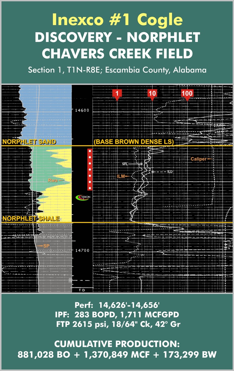
Steve Walkinshaw has over four decades of experience in the Smackover and Norphlet trends of Mississippi and Alabama. Several areas within those trends have yielded valuable prospects for the company's current Program inventory. Note - to view a second, lower resistivity Norphlet log (besides the one shown below), please click here.
Steve Walkinshaw, President, Vision Exploration
This entire site Copyright © 2022. All rights reserved.