| MAFLA Formation |
|
|
|
|
|
|
|
|
|
|
|
|
|
|
OCS Analog (SLA)
UPDIP SANDSTONE FACIES; DOWNDIP ALLOCHEMICAL FACIES; MOORINGSPORT ALSO IN PLAY
The James Lime is a carbonate member of the Lower Rodessa that has been the recipient of renewed attention following the development of two recent James Lime trends that are geographically located at opposite ends of the overall James Lime depositional area. In east Texas, the James Lime Horizontal Gas Play is maturing, with mixed results. That play focused efforts on the enhancement of gas producibility via horizontal drilling designed to intersect and drain multiple fractures within an area of the James Lime known to be tight but frequently gas-bearing. As with all such plays, some "sweet spots" were quickly located but a good part of the area originally thought to have commercial potential later turned out to be marginally economic at best, with the production of relatively high volumes of salt water.
On the southeast perimeter of James Lime well control, in the Vioska Knoll OCS area south of Mobile, Alabama, a unique James Lime Play developed in the early 1990's. This play, originally leased by Chevron, was farmed out to Samedan Oil Corporation after Chevron's first two wildcat attempts in the area were unsuccessful. Samedan and its partners drilled the discovery well for the Trend (the VK 252-1), a successful effort to move updip and, in doing so, establish gas production and encounter better porosity than that penetrated in the second, nearby Chevron dry hole (the VK 296-1). Samedan later relinquished operations and farmed out the remaining leasehold back to Chevron after drilling its second successful well, as required by the terms and conditions of the original Chevron farmout. The resulting development appears to have developed into a significant gas trend with potential reserves discovered to date having already estimated at 600 billion cubic feet of gas. In this relatively new area, which bears some similarity to those Lower Cretaceous gas plays located onshore on the west flank of the Hancock Arch, reservoir porosity averages 12% to 14% and has been observed to exceed 20% in some areas. Porosity within the James Lime usually develops 30-60 feet below a resistivity marker that many geologists utilize in mapping the top of the unit. Its reservoir fabric is one of the most heterogeneous of the Lower Cretaceous carbonate reservoirs encountered in the southern Gulf Coast, and certainly one of the least understood.
In southwestern Mississippi, the James Lime porosity transitions from a calcarenite in Jefferson Davis, Copiah, Lawrence and Lincoln Counties to a partially leached orbitulinid/millioloid/skeletal hash facies in Walthall, Marion, and Pearl River Counties (just updip of the Prospect area). In the Vioska Knoll area, the reservoir fabric is interpreted to consist of leached macrofossil and foraminiferal debris interspersed with scattered oolitic, oncolitic, and grainstone lenses. In some of the lower energy deposits, a concentration of clays contributes to significant amounts of immovable (“bound”) water contained within the reservoir matrix, a characteristic that is exacerbated by the partial leaching of the fossil debris. This carbonate "aggregate" is commonly (and accurately) described as an allochem.
Although the source of the fossil debris is presumed by many to have been derived locally from the erosion of the nearby massive reefal buildup associated with the Rodessa / Sligo shelf edge, it is the opinion of this geologist that some transportation of skeletal debris also originated in the updip areas to the north and east - as well as from small patch reefs that also grew nearby in the shallow James Lime sea.
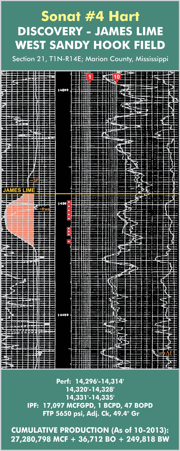
Relatively speaking, the James Lime reservoir has only recently become the focus of exploratory efforts in the South Mississippi – Southeast Louisiana – Vioska Knoll area. Strong production in the West Sandy Hook Field area (>58 BCF to date) of southern Marion County, Mississippi caused a number of James Lime tests to be drilled in the surrounding counties, leading to additional discoveries at Hub (9.3 BCF from one well), Sandy Hook, and Poplarville Fields.
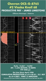
More importantly, drilling efforts in the offshore Vioska Knoll area, beginning in 1993, resulted in the discovery of prolific James Lime reserves. Several of the better Vioska Knoll wells have sustained daily gas production in excess of twenty million cubic feet of gas per day ("MCFGPD"), and one in particular – the Chevron OCS-G-8675 (VK 68) was still flowing at the rate of 10,000 MCFGPD after producing over 16 billion cubic feet of gas in approximately three years (click here to view the log across the James Lime for the VK-68 well). What is surprising about most of the prolific Vioska Knoll wells is the fact that resistivity electric logs run across the productive James Lime reservoir in almost all of these wells exhibit a “wet” profile; that is, resistivity values for productive gas wells often fall to below two m-ohms, a resistivity so low as to be immediately presumed “wet” or salt water–bearing by the casual observer. This unusually low productive resistivity profile is attributed to the presence of partially leached fossil debris, as well as some interstitial clay, which obviously impacts the log response – but not the productivity – of the James Lime reservoir in the Vioska Knoll Trend area.
The Vioska Knoll James Lime Trend appears to be oriented northwest-southeast and parallel to the strike of the Rodessa / Sligo shelf edge. A projection of the play a short distance to the north takes it onshore and across the Florida Parishes of Louisiana.
Updip of the James Lime Trend lies the Mooringsport Carbonate Gas Trend of South Mississippi, located predominantly in Pearl River and Hancock Counties on the west flank of the Wiggins Arch. The productive Mooringsport facies (as encountered in the 158 BCF Waveland Field, in Hancock County) consists of two lenses of carbonate porosity ("A" and "B") comprised principally of partially leached and dolomitized milliolid shoals, typically microfractured; the multichambered milliolid carbonate fabric is characterized by high connate water saturations and a relatively low productive resistivity profile. Other zones of leached milliolid and allochemical carbonate porosity are believed to develop elsewhere within the Mooringsport as one moves further downdip into the Florida Parishes of Louisiana. Fracturing of the poorer zones of porosity, accompanied by strong gas shows, is common throughout the Mooringsport Carbonate Gas Trend, especially in the Poplarville/Angie/Bogalusa Field areas of Pearl River County and Washington Parish. This trend is virtually unexplored and represents a promising deep gas play, especially if gas prices recover. To view the type log for (the discovery well for) Waveland Field, please click here.
Steve Walkinshaw, President, Vision Exploration
This entire site Copyright © 2015. All rights reserved.